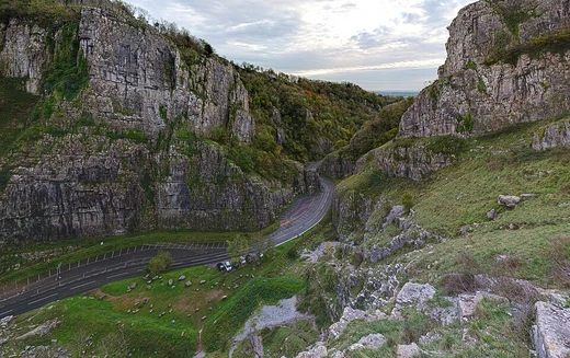
Dadès Gorges
Rugged Moroccan wadi gorges carved by the Dadès River.

The Dadès Gorges, also referred to as the Dades Valley, are a series of rugged wadi gorges carved out by the Dadès River in Morocco. The river originates in the High Atlas range of the Atlas mountains, flowing some 350 kilometres (220 miles) southwest before joining the Draa River at the edge of the Sahara. The walls of the gorges range anywhere from 200 to 500 meters (660 to 1,640 feet).
- location
- Morocco
- length
- 350 kilometers (220 miles)
- wall_height
- 200 to 500 meters (660 to 1,640 feet)
- river
- Dadès River
- rock_types
- Sandstone and limestone
- known_for
- Rose water production and dramatic gorge landscape
Lore & Background
Millions of years ago, the area which now forms the Dadès Gorges lay at the bottom of the sea. Great quantities of sediment were deposited around giant coral reefs, and over time this material became compacted into a variety of sedimentary rocks such as sandstone and limestone. Eventually, the movement of the Earth's crust caused the region to rise above the sea, forming the Atlas Mountains and surrounding landscape. The Dadès River established its course quite early in this upheaval, and the flowing water began to erode away the porous sedimentary rock of the mountains. For the majority of the year, the Dadès has a relatively weak flow, owing to the dryness of the area's climate. However, during the storm season, enormous quantities of water can be forced into the river at once, creating raging torrents with enormous erosive power. These torrents carry large amounts of debris from the source all the way down to the end of the river's source, and each piece scrapes away at the softer rock in the gorge walls, gradually enlarging and deepening the gorge with every flood season.
Reader's Guide
The southernmost gorges are known for extensive production of roses, used in the production of rose water. There are also groves of palm and almond trees. The walls of the gorges, ranging from 200 to 500 meters high, are composed of sedimentary rocks like sandstone and limestone, evidence of the ancient seabed. The Dadès River flows 350 kilometres (220 miles) southwest from the High Atlas to join the Draa River at the edge of the Sahara. Its seasonal torrents, triggered by storm season, carry debris that scrapes and deepens the gorge walls with each flood, making the gorges a dynamic landscape shaped by both tectonic uplift and ongoing erosion.
Did You Know?
- The Dadès River flows some 350 kilometres (220 miles) southwest before joining the Draa River at the edge of the Sahara.
- The walls of the gorges range anywhere from 200 to 500 meters (660 to 1,640 feet) in height.
- Millions of years ago, the area lay at the bottom of the sea, where sediment compacted into sandstone and limestone.
- During storm season, raging torrents carry debris that scrapes away softer rock, gradually enlarging and deepening the gorge.
- The southernmost gorges are known for extensive production of roses, used in the production of rose water.
More in Caves & Gorges 1-23
Spotted an error? Know more?
This is a living reference — every entry is fact-audited, and reader corrections feed straight into our audit queue. Suggest an edit · See this site's audit record