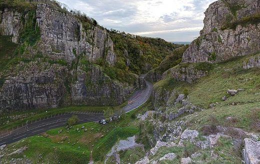
Columbia River Gorge
Canyon of the Columbia River, a national scenic area.

The Columbia River Gorge is a canyon of the Columbia River in the Pacific Northwest of the United States. Up to 4,000 feet deep, the canyon stretches for over eighty miles as the river winds westward through the Cascade Range, forming the boundary between Washington and Oregon. It furnishes the only navigable route through the Cascades and the only water connection between the Columbia Plateau and the Pacific Ocean. A popular recreational destination, the gorge holds federally protected status as the Columbia River Gorge National Scenic Area and is managed by the Columbia River Gorge Commission and the U.S. Forest Service.
- depth
- Up to 4,000 feet (1,200 m)
- length
- Over 80 miles (130 km)
- location
- Boundary between Washington and Oregon, Pacific Northwest, USA
- protected status
- Columbia River Gorge National Scenic Area (designated November 1986)
- managing bodies
- Columbia River Gorge Commission and U.S. Forest Service
- known for
- Only navigable water gap through the Cascade Range; high concentration of waterf
Verified Timeline
Lore & Background
The gorge began forming as far back as the Miocene (roughly 17 to 12 million years ago) and continued through the Pleistocene (2 million to 700,000 years ago). The most drastic changes took place at the end of the last ice age when the Missoula Floods cut the steep, dramatic walls that exist today, flooding the river as high up as Crown Point. This quick erosion left many layers of volcanic rock exposed. The gorge has supported human habitation for over 13,000 years. Evidence of the Folsom and Marmes people, who crossed the Bering land bridge from Asia, was found in archaeological digs. Excavations near Celilo Falls show humans occupied that salmon-fishing site for more than 10,000 years. In 1805, the route was used by the Lewis and Clark Expedition to reach the Pacific. In November 1986, Congress made the gorge the second U.S. National Scenic Area and established the Columbia River Gorge Commission as part of an interstate compact. The designation came in lieu of being recognized as a national park, which would require existing industries in towns along the river to relocate. The designation was initially opposed by residents fearing government encroachment and by conservationists who feared additional development.
Reader's Guide
The Columbia River Gorge is significant as the only navigable water route through the Cascade Range, connecting the Columbia Plateau to the Pacific Ocean. Its extreme range of elevation and precipitation—from 4,000 feet to sea level, and from 100 inches of annual precipitation to only 10 inches over 80 miles—creates a diverse collection of ecosystems, from temperate rainforest to dry grasslands. This diversity supports at least 13 endemic wildflower species. The gorge is a popular recreational destination for hiking, biking, sightseeing, fishing, water sports, windsurfing, and kiteboarding, with over 90 waterfalls on the Oregon side alone. Its federally protected status as a National Scenic Area, managed by the Columbia River Gorge Commission and the U.S. Forest Service, balances conservation with existing human uses. The gorge also serves as a major transportation corridor, carrying Interstate 84, U.S. Route 30, Washington State Route 14, and railroad tracks on both sides.
Did You Know?
- The Columbia River Gorge is one of only four rivers connecting the east side of the Cascade Range to the Pacific Ocean, alongside the Klamath, Pit, and Fraser rivers.
- Atmospheric pressure differentials east and west of the Cascades create sustained 35-mile-per-hour winds in the gorge, making it a popular windsurfing and kiteboarding location.
- The Oregon side of the gorge alone has over 90 waterfalls, including the 620-foot-high Multnomah Falls.
- The Missoula Floods at the end of the last ice age carved the steep, dramatic walls of the gorge, flooding the river as high up as Crown Point.
- In fall 2017, the Eagle Creek Fire burned in the gorge for three months, consuming almost 50,000 acres.
Geological Origins and the Missoula Floods
The Columbia River Gorge is a product of deep geological time. Its formation stretches back to the Miocene epoch, roughly 17 to 12 million years ago, and continued evolving through the Pleistocene, a window spanning from two million to 700,000 years ago. During that long interval the Cascade Range was still assembling itself, and the river's delta gradually migrated about 100 miles northward to where it sits today. Yet the slow, patient erosion of millions of years was not what gave the canyon its most striking character. The true sculptor arrived at the close of the last ice age, when the catastrophic Missoula Floods surged through the channel, carving the sheer, dramatic walls visible today and pushing floodwaters as far upstream as Crown Point. That rapid, violent cutting also stripped away overlying material and exposed the layered volcanic rock that now lines the gorge's flanks. The result is a water gap up to 4,000 feet deep and more than 80 miles long, threading westward through the Cascades as the sole navigable passage between the Columbia Plateau and the Pacific Ocean.
A Living Mosaic of Ecosystems
Few places on Earth compress such a range of climates into a single corridor. Within the 80-mile span of the Columbia River Gorge, annual precipitation drops from roughly 100 inches on the western rim to just 10 inches at the eastern end, and elevation swings from 4,000 feet down to sea level. The western reaches support a lush temperate rainforest where bigleaf maple, Douglas fir, and western hemlock stand draped in epiphytes. Moving eastward past Hood River and toward The Dalles, the character shifts to a transitional dry woodland of Oregon white oak, ponderosa pine, and cottonwood. Beyond that, the forest thins into open grasslands punctuated by scattered lodgepole and ponderosa pine. These isolated micro-habitats have nurtured a remarkable roster of endemic life, including at least thirteen wildflower species found nowhere else. Among the named endemics are Lomatium columbianum, Lomatium klickitatense, Lomatium suksdorfii, Penstemon barrettiae, and Primula poetica. The sheer variety of niches packed into one canyon makes the gorge one of the most ecologically dynamic landscapes in the Pacific Northwest.
Thirteen Thousand Years of Passage
Long before any paved road or steel rail, the gorge served as a vital artery of human movement. Archaeological evidence ties the Folsom and Marmes peoples, descendants of those who crossed the Bering land bridge from Asia, to the landscape. Excavations near Celilo Falls, a few miles east of The Dalles, reveal humans fished for salmon at that site for over 10,000 years. Native communities used the river and the overland route across Lolo Pass on the north flank of Mount Hood to trade at Celilo Falls for millennia. In 1805, the Lewis and Clark Expedition followed the same waterway to reach the Pacific. Steamboat lines and railroads later layered onto the corridor; today BNSF freight runs along the Washington shore while Union Pacific operates on the Oregon side. The Columbia River Highway, completed in the early 1900s, became the first major paved highway in the Pacific Northwest. Yet Bonneville Dam and The Dalles Dam ultimately submerged Celilo Falls and the rapids that had defined river travel for thousands of years, with Celilo's flooding occurring in 1957.
Wind, Water, and the Scenic Area Compromise
The deep cut of the gorge creates a natural wind tunnel. Atmospheric pressure differentials on either side of the Cascades funnel air through the canyon, generating sustained 35-mile-per-hour winds that make the area a magnet for windsurfing and kiteboarding. In winter, those same dynamics pull very cold east winds toward the western mouth and set the stage for snow and ice storms. The water draws crowds in a different way: the Oregon side alone boasts over 90 waterfalls, many lining the Historic Columbia River Highway, including the celebrated 620-foot Multnomah Falls. Hiking, biking, fishing, and sightseeing round out the scene, with trails and day-use sites maintained by the Forest Service and state parks on both sides of the line. In November 1986, Congress designated the gorge the second U.S. National Scenic Area, creating the Columbia River Gorge Commission under an interstate compact. The experimental status was chosen in lieu of national-park recognition, which would have forced existing industries in riverside towns to relocate. The plan initially drew opposition from residents wary of government restrictions—down to building paint colors—and from conservationists who wanted stronger protections.
More in Caves & Gorges 1-23
Spotted an error? Know more?
This is a living reference — every entry is fact-audited, and reader corrections feed straight into our audit queue. Suggest an edit · See this site's audit record